Open Source●●●Banger
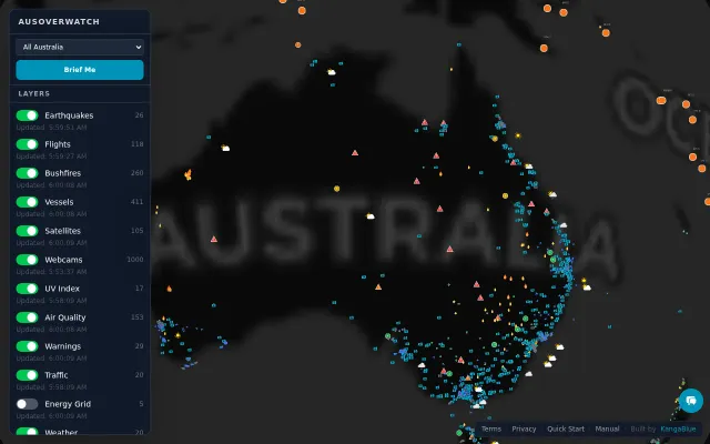
I built a real-time OSINT dashboard pulling 15 live global feeds
Tracks jets, ships, satellites, and earthquakes live on one unified dark-ops map.
WizardryCrowd PleaserRabbit Hole
vancecookcobxin
3121233mo ago
GPU-accelerated 30K object rendering is impressive, but the space tracking category already has Heavens-Above and N2YO.
Satellite operators, space situational awareness analysts, orbital mechanics researchers
Heavens-Above · N2YO · Orbiton
We built Heimdall (heimdallspace.com) because the existing tools for space situational awareness are genuinely painful to use: clunky interfaces, fragmented data sources, slow rendering. The ones that aren't are locked behind enterprise solutions. We thought the foundation of this should be open and accessible.
The goal is a satellite observability platform: one place that gives operators complete, real-time insight into their assets and the orbital environment around them. Today's release is the foundation—aggregating and rendering the full public space catalog (30,000+ objects) in real time.
How it works technically:
- SGP4 propagation running across web workers, computing positions every few frames
- Go backend ingesting TLEs hourly from Space-Track.org with daily metadata enrichment from GCAT
- React + Three.js frontend rendering 30,000+ objects as GPU point sprites with custom GLSL shaders
- 8K Earth textures with accurate solar-positioned day/night cycle
- Self-hosted on a VPS
Any feedback is appreciated. We'd also love technical feedback on the propagation approach, data pipeline, or anything that looks wrong or could be done better. We're looking for professionals in the space industry who might be able to provide real-world insight into what they want from the platform. We're early and building in the open, so this is a real ask.
Tracks jets, ships, satellites, and earthquakes live on one unified dark-ops map.
Beautiful Australia-specific data aggregation, but Google Maps already shows most layers.
VLM-based satellite detection sounds good until you remember YOLO and specialized models handle occlusion better.
Tile-based VLM inference with coordinate projection, but dense objects still need YOLO.
MCP server integration brings AI workflows to ffmpeg parallel rendering.
First API solving the actual orbital compute placement problem with SGP4 physics, not simulation.